Archaeology in the Park
Outlet River Bridges
The meandering Outlet River that bisects the East Lake sandbar has been home to at least four bridges in its history.Click on any image to view/download a higher-resolution version.
For non-profit use only; please respect our image copyright.

|

|

|

|
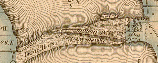
The 1863 Tremaine Map and Google Earth views show the location of these first two bridges. That was the site of the original river crossing until at least 1932. Looking closely at the Tremaine Map, it's interesting to note the access road at the south end of the Outlet Beach that connects with what is now County Road 18. Bisecting the properties of W. Clark and P. & J. Huff, that right of way, still public, is presently marked by a green gate just before County Road 18 curves east to Cherry Valley.
By 1880, the north side of the river on the sandbar was owned by S. Trumpour and G.W. Weeks; the south side was owned by A. and M. McDonald.

|
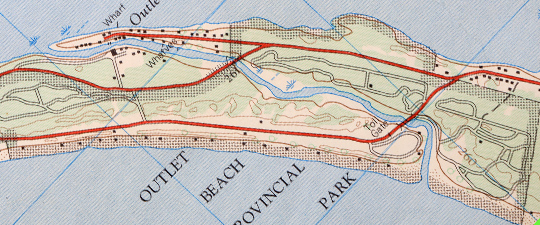
The two newer bridges, one on County Road 18 and the other connecting the Outlet River Campground to the beach were built (before 1968). It's interesting to note that in 1968, the southern entrance to the park was open to traffic, with an toll-gate located just north of the bridge at the Amphitheatre parking area as shown below on this 1968 topographical map section.

|
