County and Sandbanks Historical Maps
To get a better idea of Sandbanks' history, one of the best ways is to view archival maps of the area. Here is an ongoing collection of useful maps.
Note: Some of these maps are large files...
- 1632 Samuel de Champlain Map
- 1656 Map of New France
- 1730 Map of New France
- 1745 Map of New France
- 1783-1800 United Empire Loyalist Settlement Routes, Blakely powder-horn map
- 1794 North America, Lake Ontario/ New York state section
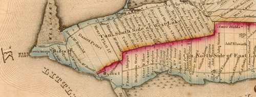
- c. 1800 East Lake Survey
- c. 1800 West Point Survey
- 1812 Willson Conger survey of Hallowell Township
- 1829 Hallowell Township Survey
- 1833 Hallowell Township Survey
- 1835 William Rorke Survey, East and West Lake areas
- 1835 William Rorke Survey, West Point detail
- 1852 John Roche map of Block H, West Point
- 1863 Tremaine Map, Prince Edward County (17 Mb .jpg file, 6000 px x 4850 px)
- 1863 Tremaine Map, East and West Lakes (4200 px x 4200 px .jpg file)
- 1880 McGill County Maps of Ontario
-
- 1880 Prince Edward County Map, Ameliasburgh Township
- 1880 Prince Edward County Map, Athol Township
- 1880 Prince Edward County Map, Hallowell Township
- 1880 Prince Edward County Map, Hillier Township
- 1880 Prince Edward County Map, North Marysburgh Township
- 1880 Prince Edward County Map, South Marysburgh Township
- 1880 Prince Edward County Map, Sophiasburgh
- Extent of Sand Drift on Block H, 1852 - 1922
- 1932 Topographical Map of West Point
- 1967 Hallowell Township Lot Plan
- 1968 Topographical Map of West Point
- 1968 Topographical Map of Outlet Beach
- Sandbanks Google Earth Satellite/Map view
- Winter Ski Trails Map 2020
- Winter Ski Trails West Map 2020
- Todd Norris Cedar Sands Trail Map, c. 1990

